This page offers a guide to the physical Roman remains to be seen at the important walled towns of Ancaster, Caistor and Horncastle.
Ancaster

1. St Martin’s Church
Although St Martin’s church is not in itself Roman, it is worth mentioning two Roman related things that can be found there. The first is a small display of textual material inside the church, not quite large enough to feature on my museums page, but interesting nonetheless.

The second can be found located on the wall of the churchyard in the form of a modern reconstruction of the stone carving of three mother goddesses (the Deae Matres), found within the churchyard in 1831.

Just for comparison, here is the original sculpture, on display at The Collection in Lincoln.

2. Sarcophagi in the cemetery


The modern cemetery a short walk up Church Lane from St Martin’s Church occupies part of a Roman cemetery, from which more than 300 burials are known. The cemetery is one of the largest known from Lincolnshire and, as the burials are all late and potentially Christian, also one of the most important. Two Roman stone sarcophagi have been placed on view in the modern cemetery.
The cemetery is also the site where a 2001 Time Team excavation discovered an inscription to the god Viridius, being re-used in a later burial. You can see all of the known Viridius inscriptions in my post here.
Although not visible in the landscape today, the cemetery is also the site of the discovery of a pair of early Roman ditches, believed to be part of a temporary marching camp on the site before the establishment of the town.
3. Southern defensive ditch

The defenses of the south east corner of the town survive in good condition, but sadly are now impossible to properly access by the public (if someone knows of an access route I don’t then please tell me!). Traces of the southern defensive ditch can be seen from the A153, just east of the junction with the B6403, which is itself the Roman Ermine Street which ran north / south through the town.
The scale of the surviving defences on the eastern side, not currently publicly accessible can be seen from this 1960s(?) photograph in The Collection’s archives.

Caistor
Roman Caistor is a fascinating yet somewhat mysterious site. Excavations of small elements of the walled enclosure have enabled the line of the wall to be established, revealing it to be an irregular shape. Caistor is in many ways a sister site to Horncastle (see below) in that the walled enclosure dates to the late 3rd or 4th Century and may have served as part of the late Roman coastal defensive network. No evidence of structures within the walled enclosure have been discovered, leaving the nature of the enclosure enigmatic.

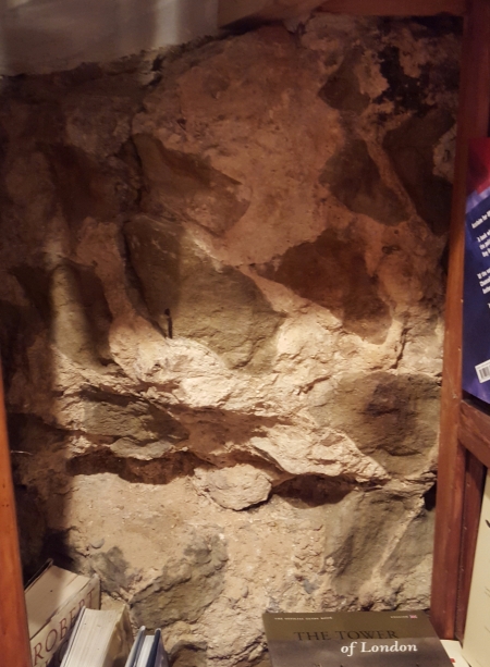
1. Section of the southern wall in the churchyard of the Church of St Peter and St Paul


The only physical remains of Roman Caistor to still be seen can be found at the south of the churchyard of the Church of St Peter and St Paul. The section of wall, now lichen covered, is located behind an ugly fence and the decision to allow a house to be built close to it makes it difficult for the face of the wall to be seen.
Note – a very interesting series of tweets by Peter Lorimer (@pighilltweets) has revealed other possible surviving sections of the Caistor wall. I have not included these here at present but am investigating them and will add them in due course when their exact location, visibility to the public and Roman origins can be confirmed.
Horncastle
Roman Horncastle consisted of two distinct elements, a large unenclosed settlement to the south of the modern town and a walled enclosure occupying a defensive position between the Bain and Waring rivers, where the heart of the modern town is located. The undefended settlement may have Iron Age origins but was definitely occupied between the 1st and 4th Centuries. The walled enclosure, just as at Caistor (see above), was constructed in the late 3rd or early 4th Centuries and is more problematic to interpret. Small but well defended, the enclosure may have been a military installation constructed as part of late Roman coastal defenses and perhaps housing a cavalry unit, though a dearth of finds from within the enclosure makes certainty difficult.
The visible remains in the town all relate to the defended enclosure. Some large surviving wall sections exist in private gardens and are not visible from public areas, though may be viewable on certain open days at the discretion of the owners. Because these are not available for the casual visitor, I haven’t included them here, but are worth seeing if you get the chance, and there are some images on the Horncastle History and Heritage Society’s website.

1. Wall section in Horncastle Library
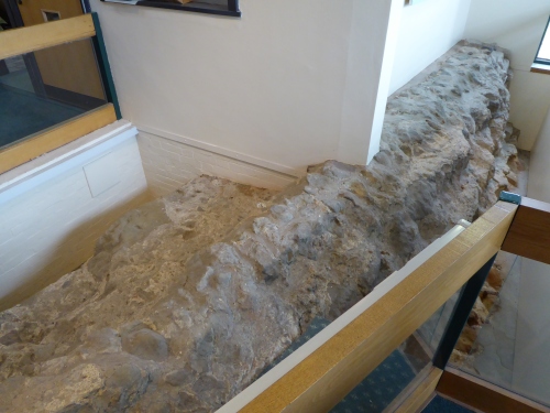
One of the largest sections of the wall can be found inside Horncastle Library. The section is part of the south eastern length of wall, excavated in 1968, and survives now as a low length of wall core around which the library is designed. A nice element of this section of wall is the display that has been put up behind it, setting out the context of the wall from William Stukeley’s 1722 map of the town onwards.

2. Site of south eastern bastion

If you leave Horncastle Library and head around to the eastern side of the building, you can see the position of the walled enclosure’s circular south eastern bastion marked out in white cobbles. Although not an original section of wall, this more than any other visible remains gives a sense of the scale and thickness of the defences.
3. North eastern bastion

The north eastern bastion is now in a rather sad state, but can be seen on Dog Kennel Lane, just next to a private car park, abutted by brick walls and covered with plant life.
4. Section of wall in Jabberwock Books
Jabberwock Books is located just north of the Market Square on St Lawrence Street and, as well as being an excellent second hand bookshop, also contains a section of the wall. Appropriately located next to the history and archaeology section towards the rear of the shop, the Roman wall actually survives as the wall of the premises, but a small section has been left clear of shelves by the owner for people to see.
5. Section of the western wall

Located at the end of Manor House Street, this section of wall core is now built into the wall of a community centre. The section is part of the western wall, just south of where the western gateway was located. This section of wall has sadly suffered in recent decades, and voids in the mortar attest to where stones have been illegally taken away.
6. Section of the southern wall

It has to be said that this is not the most exciting section of Roman wall to be seen within the bounds of the Empire, but is included here for the sake of completeness. This small and easy to miss fragment is located to the south of St Mary’s Church, on St Mary’s Square near the junction with Jubilee Way. Ironically, this small and rather sad section marks the end of one of the most impressive surviving sections of wall, located in the gardens of private properties to the west, which also include a fragment of the south western bastion.
7. Section of the southern wall

This section of the southern wall is located in a small private car park at the southern end of Church Lane, near the junction with Wharf Road. The solidity of Roman wall construction is evidenced by the fact that the wall serves to support later brick walls built on top of it.

Three years later, I just found this post. Regarding Caistor: There are more bits of possible Roman wall all over the place, in addition to those identified by Peter Lorimer. In particular, there’s a long-ish stretch in the Grammar School grounds, heavily restored.
LikeLike